


Route Planning – Where to Start?

Whether your new to running or been running for years, planning and finding a new running route is still something to get excited about.
I for one have been living at my current house for nearly 5 years and it’s taken me until now to discover some of the most beautiful off road running trails and tracks that I didn’t know existed. In the past I have tended to stick to the roads and have fallen victim to constantly checking my Garmin to make sure my pace was what it ‘should’ be. However exploring new routes across country fields and through woods has given me the opportunity to enjoy the simple element of running, and focus on running to how I feel. You can’t really compare your pace when running off road and on uneven undulating surfaces, and over the last few months I’ve really learnt to embrace it.
Tips for planning new routes
OS Maps
If you have access to an Ordinance Survey map this is a great place to start.
I recently purchased an OS map for my local area and have found it really useful for identifying footpaths that I previously didn’t know were there. OS maps cover urban areas as well as the countryside, so they are great if you want to plan a new run right from your front door out into the countryside. If you want to venture further afield you can also use them the map to plan a route in an area of interest to you.
I then laid out the map and spent an evening studying it to spot all the footpaths and bridleways that I thought would make a suitable a run route and it was as simple as that.
I personally haven’t been taking the map with me when I run, I just try to remember the route as best as I can, but the key things is to look out for the Green public footpaths signs and remember to always stick to public rights of ways.
Bing Maps
If you don’t want to purchase an OS map Bing maps has a feature where you can change the map setting to OS.

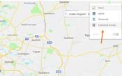
You can then zoom in and out to change the scale of the map. The more you zoom in the easier it will be to spot the footpaths.
If you’re unsure of the map symbols you may find this document helpful.
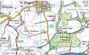
Leeds country way
We are lucky in Leeds to have the Leeds Country Way which is a 62 mile footpath that goes around Leeds taking in some of the most varied countryside.
The route is split up into 4 main sections, and you can find maps and information about each section here.
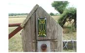
If you haven’t ever ran a section of the route its definitely one to try. The route is signed by green and yellow waymark arrows that feature the owl motif.
If you fancy racing a section of the LCW Kippax Harriers organise an annual team relay race to take in the whole of course. The race has unfortunately been cancelled for 2020 due to Covid-19, but keep your eyes peeled for 2021.
Other tools that you can use to find a new route are:
The Run Leeds route page
Map my run – Useful for plotting the distance of a run before hand.
Strava – Good for pinching routes from fellow runners!
The main thing when planning a new route is to have fun with it and don’t worry about how fast you are running! It also really important that if you do go out to discover a new route don’t forget about safety elements. Always tell someone where you are going and a rough time you will be back, take your phone if you wish, don’t run anywhere you feel unsafe to do so.
If you discover a great new route near you, let us know and we can add it to out route page to share with the running community.